Tadiandamol Trek (2026): Coorg Highest Peak, Route and Weekend Groups
Complete guide to the Tadiandamol trek from Bangalore with route, difficulty, best season, and group departure options for 2026.
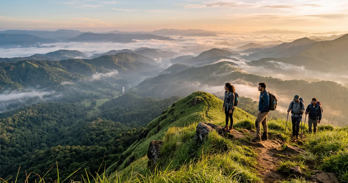
Tadiandamol is 1,748 metres and the highest peak in Coorg district. The name comes from Kodava language: "tadiyanda" means a large, flat place, and "mol" means hill. The summit is a broad grassy ridge, not a sharp point. On a clear morning, you can see the Brahmagiri range to the south and the Western Ghats fading into Kerala.
The trek itself is 5 km one way from Nalaknad Palace, the ruined hunting lodge of Kodagu kings that serves as the trailhead. The path climbs through shola forest patches and open grassland. No ropes, no scrambling, no technical sections. Just sustained uphill on a trail that gets steep in the last kilometre.
From Bangalore, the full weekend plan is: drive 270 km to Madikeri on Saturday morning, trek up and back on Saturday afternoon or Sunday morning, drive home Sunday evening. Some groups do it as a single overnight trip with a pre-dawn summit push.
TL;DR
- 5 km one way from Nalaknad Palace base to summit (1,748 m), 3 to 4 hours up
- Moderate difficulty: no technical climbing, but sustained 600 m elevation gain on steep grass
- Best season: October to February for views and dry trails
- Forest permit required (operators handle it; solo trekkers get it in Madikeri)
- Group departures from Bangalore run most weekends October to March; check current trips
How hard is the Tadiandamol trek?
If you have done two or three weekend treks before, Tadiandamol will feel challenging but doable. If this is your first trek, it will hurt.
The numbers: 5 km, 600 metres of elevation gain, 3 to 4 hours up, 2 to 3 hours down. The first 2 km through shola forest are gentle. Then the trail opens to grassland and steepens. The final kilometre to the ridge is the hardest, with loose soil on a 40 degree slope in places.
There is no scrambling or rock climbing. Your hands stay in your pockets (or on your knees, if the slope is winning). The challenge is cardiovascular, not technical. Good shoes with ankle support matter more than upper body strength.
One thing nobody mentions in blog posts: the descent batters your knees. The same steep grass that was hard to climb up is harder to walk down without slipping. Trekking poles make a real difference on the way back.
The route from Nalaknad Palace to summit
The standard route starts at Nalaknad Palace (about 1,150 m elevation). The palace itself is worth 10 minutes of your time before you start. It is a 19th century two-storey structure with carved wooden pillars, now partially restored by ASI.
First 2 km: Forest section. The trail enters dense shola forest immediately after the palace. It is shaded, cool, and the gradient is gentle. You will cross two small streams (dry by December). The path is marked with occasional forest department paint on rocks.
2 to 4 km: Grassland transition. The canopy breaks and you step into waist-high grass with scattered trees. The gradient picks up. You can see the summit ridge from here, which is both motivating and demoralizing because it looks close but takes another hour.
4 to 5 km: Summit push. Open grassland, steep, exposed to sun and wind. No shade, no water. In monsoon, this section is knee-deep grass with invisible trail markers. In winter, the grass dries golden and the path is obvious. The summit is a broad flat area (that "tadiyanda") with a small cairn.
What you see from the top
On clear days (most common November to January), the Brahmagiri range dominates the south. To the west, the ghats drop toward Kerala. Nagarhole National Park's forest canopy stretches north. The Kaveri river valley is visible on the eastern side.
Clouds roll in fast. A morning that starts clear at 7 AM can be completely socked in by 9 AM. This is Coorg, and moisture comes from the Arabian Sea with no warning. If you want summit views, start early.
I will be blunt: sunrise from Tadiandamol in December is one of the best things you can experience on a weekend from Bangalore. The golden light on those grasslands with mist in the valleys below is worth the 5 AM alarm and the drive.
Best time to visit Tadiandamol
October to February (recommended). Cool temperatures (8 to 15°C at the summit in the morning), dry trails, and clear views. December and January are best for photography. The grass turns golden, which photographs better than the monsoon green anyway.
June to September (monsoon). The grasslands turn electric green. Wildflowers bloom. Waterfalls appear on cliffs that are dry the rest of the year. But: the trail gets extremely slippery, leeches are aggressive in the forest section (carry salt and long socks), and cloud cover means zero summit views on most days. If you are OK with the trek being about the journey and not the destination, monsoon Tadiandamol has its own beauty.
March to May (summer). Hot. The exposed summit ridge gets direct sun with no shade for the last kilometre. The grass is dead and brown. Water sources dry up. Possible, but unpleasant. Start before 5 AM if you must.
Getting to Tadiandamol from Bangalore
The base village is Nalaknad, about 270 km from Bangalore. Budget 5 to 6 hours of driving.
By car: Take NH 275 to Mysore (3 hours), then SH 88 through Kushalnagar to Madikeri (2 hours), then 18 km to Nalaknad. The road to Nalaknad is narrow but paved. Parking is available at the palace.
By bus: KSRTC runs Volvo and Airavat buses from Majestic (Kempegowda Bus Station) to Madikeri. Journey time is about 6 hours. From Madikeri, hire a local auto or jeep to Nalaknad (18 km, about 400 to 600 rupees).
With a group trip: Most operators do Bangalore pickup on Friday night or Saturday at 5 AM, reach base by midday, trek in the afternoon or early morning, and return Sunday evening. This removes all logistics hassle. Check group treks from Bangalore for upcoming departures.
What to pack for Tadiandamol
The essentials, nothing more:
Shoes with good grip and ankle support. Trail runners work in dry season; hiking boots are better in monsoon. Slippers and sports shoes are not OK on the steep sections.
2 litres of water minimum. There is no reliable water source after the first 2 km. In summer, carry 3 litres.
A windbreaker or light jacket. The summit is exposed and windy even on warm days. Temperature drops 6 to 8°C from base to top.
Sunscreen and a cap for the exposed final section. The sun at 1,700 metres hits different than at sea level.
In monsoon: leech socks, a rain jacket (not just an umbrella), and a dry bag for your phone and camera.
Group treks vs solo: which works better?
For Tadiandamol specifically, group treks solve three problems. First, the forest permit: operators handle paperwork in advance, which saves you a trip to the Madikeri forest office. Second, transport to Nalaknad: most groups include a Tempo Traveller or Innova from Bangalore, which means you sleep while someone else navigates the Coorg hairpins. Third, they know the trail. In monsoon, when the grass swallows the path, having a local guide is the difference between reaching the summit and wandering the ridgeline lost.
Going solo works fine in dry season (October to February) when the trail is obvious and the permit counter is open. You save money, set your own pace, and avoid the 20-person groups clogging the trail.
A weekend group trek from Bangalore for Tadiandamol typically costs 3,500 to 5,500 per person including transport, camping or homestay, meals, permits, and guide. Compare operators on TripzSearch to see what is included and read reviews from actual trekkers.
Nearby things worth combining
Tadiandamol alone fills one day. If you are driving to Coorg anyway, stretch it to a two-day trip.
Mandalpatti viewpoint (25 km from Madikeri by jeep road). The views rival Tadiandamol on clear mornings, and you drive up instead of hiking. Go at sunrise.
Abbey Falls (10 km from Madikeri). A short walk to a 21 metre cascade in a coffee plantation setting. Good for the afternoon after your morning trek.
Madikeri town. The fort, Raja's Seat, and the town market sell Coorg coffee, homemade wine, and wild honey. Not spectacular, but pleasant for an hour of walking.
Nagarhole National Park (50 km from Madikeri). If you have an extra day, a morning safari here has a good chance of elephant, gaur, and occasionally tiger or leopard sighting.
Permits and fees
The Kodagu Forest Department controls access to Tadiandamol. A permit is required for all trekkers.
Current fee: approximately 300 to 500 rupees per person (subject to change; confirm when booking). Groups pay per head. The permit limits daily entries to prevent overcrowding, which is why weekend slots in peak season fill up.
For group treks, your operator handles this. For solo or self-organised treks, visit the DFO office in Madikeri (open 10 AM to 5 PM on weekdays) or check if online booking is available on the Karnataka Forest Department portal.
The permit process is the main reason many trekkers choose group departures. The office is not open on weekends, which means you either go on a weekday, get the permit Friday before, or book with someone who handles it for you. A small hassle that has killed more spontaneous Saturday plans than the weather.
Frequently asked questions
- Is Tadiandamol trek difficult for beginners?
- Tadiandamol is moderate, not beginner friendly in the way Nandi Hills is. The trail gains about 600 metres over 5 km with some steep grassy sections. If you can walk uphill for 3 hours without stopping, you will manage. People with zero trekking experience should try Skandagiri or Savandurga first.
- What is the best time for Tadiandamol trek?
- October to February is ideal: cool weather, clear views from the summit, and dry trails. Monsoon from June to September turns the grasslands bright green but makes the trail slippery and leeches come out in numbers. Avoid March to May when the heat makes the exposed final ridge miserable.
- Do I need permission to trek Tadiandamol?
- Yes. The forest department requires an entry permit. Most group trek operators handle this in advance. If you go independently, get the permit from the Kodagu Forest Department office in Madikeri. The permit costs around 300 to 500 rupees per person and limits daily entries.
- How do I reach Tadiandamol from Bangalore?
- Drive or take a KSRTC bus to Madikeri (about 270 km, 5 to 6 hours). From Madikeri, the trek base at Nalaknad Palace is 18 km by road. Most group treks include pickup from Madikeri. If driving yourself, park at Nalaknad and start walking.
- Can I camp at Tadiandamol summit?
- Camping on the summit itself is not officially permitted by the forest department. However, some operators set up camps at the base or mid trail clearings. Check with your operator before assuming overnight stays are included. The summit is exposed with no tree cover, which makes it cold and windy after dark.