Spiti Valley Road Trip (2026): The Complete Route Guide and When a Group Trip Beats Self-Drive
Plan your Spiti Valley road trip with routes from Manali and Shimla, costs, permits, best months, and group trip options that handle the hard parts for you.
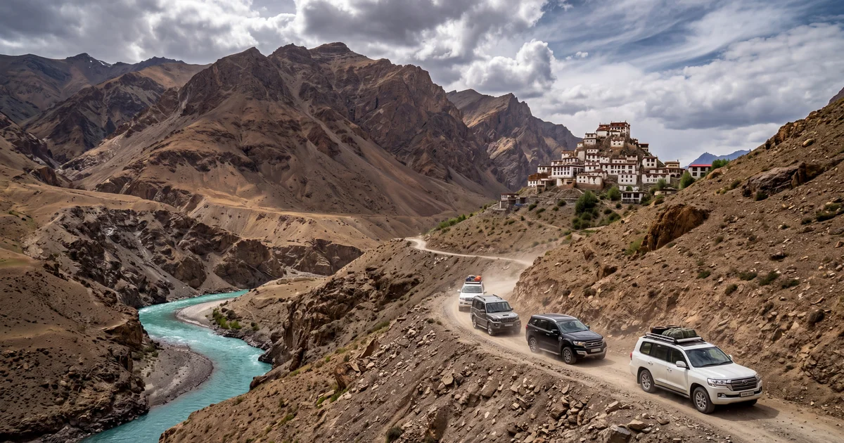
Spiti Valley sits at an average altitude of 4,270 metres in Himachal Pradesh, wedged between Tibet and the main Himalayan range. The landscape looks nothing like the rest of India. Brown, treeless mountains. Buddhist monasteries on cliff edges. Villages with 40 to 60 residents where the nearest hospital is a 5 hour drive away.
A Spiti Valley road trip is one of those things people talk about for years before doing. Some never get past the talking. The roads are genuinely difficult, the distances deceptive, and the altitude catches people off guard. But if you plan correctly (or let someone else plan for you), it is among the best drives you can do in this country.
TL;DR
- The full Spiti circuit (Shimla entry, Manali exit or reverse) takes 9 to 11 days and covers roughly 750 km of mountain roads.
- Best months: June to September. The Manali route closes by mid October.
- Self-drive works if you have mountain driving experience and a capable SUV. First timers should seriously consider a group trip.
- Budget roughly 35,000 to 50,000 per person self-drive, or 18,000 to 35,000 for a group departure.
- Inner Line Permits are needed for Pin Valley and areas near the Tibetan border. Get them in Kaza or Reckong Peo.
Which Route Should You Take Into Spiti?
Two roads lead to Kaza, the district headquarters. Each has a different character.
The Shimla side (NH-5 via Kinnaur): You drive through Rampur, Narkanda, Sarahan, and Reckong Peo before entering Spiti near Sumdo. The road is better maintained, the altitude gain is gradual (you go from 2,200m at Shimla to 3,800m at Nako over 3 days), and the landscape shifts slowly from green pine forests to barren brown. This route stays open for most of the year, though landslides between Jeori and Sangla can block it in heavy monsoon.
The Manali side (via Rohtang and Kunzum): You climb from 2,050m at Manali to 3,978m at Rohtang in under 50 km, then drop into the Chandra valley and climb again to Kunzum La at 4,590m before descending to Kaza. The road between Gramphoo and Lossar (roughly 60 km) is mostly unpaved, with water crossings that can get thigh deep in July. This side opens around late June and closes by mid October.
The smart move: enter from Shimla, exit via Manali. You acclimatize gradually, see the best of Kinnaur first, and finish with the dramatic Kunzum pass descent into Manali. Reversing works too, but you lose the altitude buffer.
What Does a 10 Day Spiti Itinerary Actually Look Like?
A realistic day by day breakdown follows. Not the "if everything goes perfectly" version.
Days 1 to 2: Shimla to Sangla (via Rampur and Karcham). About 230 km, split across two days because the road beyond Rampur is narrow and truck heavy. Sangla valley is at 2,680m and makes a good first acclimatization stop. The Kamru Fort and Bering Nag temple are walking distance from most guesthouses.
Day 3: Sangla to Nako (via Reckong Peo). Pick up your Inner Line Permit at the DC office in Reckong Peo. The drive to Nako is 5 to 6 hours, climbing to 3,660m. Nako village has a sacred lake and an 11th century Buddhist monastery.
Day 4: Nako to Tabo. Short driving day, about 3 hours. Tabo Monastery dates to 996 AD and contains murals that UNESCO recognizes. Use the extra time to walk the cave hermitages on the hillside above town.
Day 5: Tabo to Kaza (via Dhankar). Another short drive with a detour to Dhankar Monastery, perched at 3,890m with views over the confluence of the Spiti and Pin rivers. Arrive Kaza by afternoon. This is your base for 2 to 3 days.
Day 6: Kaza, Hikkim, Langza, Komic. A loop through the highest villages. Hikkim has the world's highest post office at 4,400m. Langza has a massive Buddha statue and fossilized marine life (yes, at 4,200m). Komic has a monastery and probably the worst road surface of the entire trip.
Day 7: Pin Valley. A side trip into Pin Valley National Park, home to the snow leopard and ibex. The road is narrow and rough, but the scenery is extraordinary. Mud Village at the end of the road has a population of about 20.
Day 8: Kaza to Chandratal (via Kunzum La). The big day. You cross Kunzum Pass at 4,590m and descend to Chandratal lake (4,300m). The lake access road is 14 km of deeply rutted track. Camp here overnight; the colour of the water at sunrise earns the name "Moon Lake."
Day 9: Chandratal to Manali (via Gramphoo and Rohtang). This stretch is where most self-drive plans get humbled. The 60 km between Batal and Gramphoo has no pavement, multiple water crossings, and sections where the road is literally a riverbed. Start early. Expect 8 to 10 hours for what looks like 120 km on a map.
Day 10: Buffer day in Manali or travel onward. You will need it. Not for tourism, but because your body and your car both need a rest after those last two days.
How Much Does a Self-Drive Spiti Trip Cost?
The numbers below assume two people sharing an SUV rental and guesthouses (not homestays, which are cheaper but less available in remote sections).
SUV rental with driver for 10 days: 25,000 to 40,000 total (varies wildly by season and vehicle). Fuel for the circuit: roughly 8,000 to 10,000. Accommodation: 1,500 to 3,000 per night for a double room in Kaza, less in smaller villages. Food: 500 to 800 per person per day. Permits and miscellaneous: about 1,000.
All in, per person cost lands between 35,000 and 50,000 for a 10 day trip. That is without the cost of getting to Shimla or back from Manali.
The honest caveat: fuel stations are scarce between Kaza and Manali. Fill up at Kaza. The next reliable pump is in Manali, 200 km and a full day's driving away. Carry a 10 litre jerry can if you are in a petrol vehicle.
When Does a Group Trip Make More Sense Than Self-Drive?
This is not a gatekeeping question. Spiti genuinely separates experienced mountain drivers from everyone else. Here is when you should book a group departure instead:
You have never driven above 3,000m. Altitude affects judgment and reaction time. At 4,500m, even experienced drivers find themselves making mistakes they would not make at sea level.
You do not own or cannot rent a proper SUV. The Manali side will damage a sedan. That is not a maybe.
You are going solo. Breakdowns in Spiti mean waiting 4 to 8 hours for help, sometimes longer. A group trip carries spare vehicles and tools.
You want to keep costs down. Group trips share the vehicle, fuel, and accommodation costs across 8 to 15 people. An operator can get you from Delhi and back for 18,000 to 25,000 per person, meals included. The same itinerary self-planned costs 40,000+ per person.
You value your leave days. Planning Spiti logistics (permits, fuel stops, guesthouse availability, road condition updates) takes 15 to 20 hours. A group operator does it for you. You show up with a bag.
Browse fixed-departure group trips that cover the Spiti circuit, or filter by Himalayan routes to see what is departing in your window.
What Permits Do You Need and Where Do You Get Them?
Indian citizens do not need a special permit to visit Kaza or drive the main Spiti road. But areas within 40 km of the Tibet/China border require an Inner Line Permit (ILP). This includes:
- Pin Valley National Park
- Tabo (technically, though enforcement is lax)
- Areas beyond Sumdo on the Kinnaur side
Get the ILP at the District Commissioner's office in Reckong Peo (Kinnaur side) or Kaza (Spiti side). It takes 30 minutes and costs nothing for Indian nationals. Carry 4 passport photos and ID copies.
Foreign nationals need an ILP for the entire Kinnaur and Spiti stretch. Apply at the SDM office in Shimla or Reckong Peo at least 2 days in advance. Group operators handle this for you, which is another reason foreign travellers almost always go with an organized trip.
What to Pack That Most Lists Forget
Every Spiti packing list mentions thermals and sunscreen. Most miss the things that actually matter above 4,000m.
Bring a pulse oximeter. At 4,500m your SpO2 drops to 85 to 88%. That reading tells you whether your headache is dehydration or early altitude sickness that needs descent. Costs 500 rupees and weighs nothing.
Withdraw cash before you leave Reckong Peo. ATMs in Kaza run out of money by the weekend. The ones in Tabo and Nako work intermittently at best. Carry 15,000 to 20,000.
Download offline maps or carry a printed one. Google Maps has gaps in Spiti. The road between Lossar and Gramphoo is not always shown correctly, and reroutes due to water crossings will not appear on any app.
Ask your doctor about Diamox (Acetazolamide) before the trip. Many trekkers and drivers take a low dose starting 24 hours before crossing 3,500m. It will not prevent altitude sickness entirely, but it turns a wasted day into a manageable headache.
The Roads: What Is Actually Dangerous and What Is Just Uncomfortable?
Most of the Spiti circuit is uncomfortable, not dangerous. The Shimla side is a normal hill road for 80% of the distance. Narrow, truck heavy, occasional landslide debris, but paved and passable in any vehicle.
Three sections are genuinely difficult.
Gramphoo to Lossar (Manali side). 60 km of unpaved road. Water crossings that are ankle deep in morning and thigh deep by afternoon (glacial melt). Loose scree. No guardrails. The section between Batal and Chhota Dara is the worst. In 2024, a cloudburst blocked this stretch for 3 days.
Kunzum Pass approach. The last 10 km before the pass have hairpin turns on loose gravel at 4,400m+. Visibility drops to 20 metres when clouds roll in, which happens by early afternoon most days.
Chandratal access road. 14 km of deeply rutted single track. Passing oncoming vehicles requires reversing to a wider point. The road was never designed for the traffic it now gets. Allow 90 minutes for 14 km.
Everything else? Bumpy, slow, occasionally nerve-wracking when a truck appears on a blind corner. Not technically difficult if you keep your speed under 30 kmph and stay alert.
Best Months to Go, Month by Month
June: The Manali route opens mid to late June. Snow still lines the road at Rohtang and Kunzum. Chandratal may still be partially frozen. Accommodation in Kaza is less crowded.
July: Full access everywhere. Water crossings on the Manali side are at their peak. Expect 2 to 3 hours of afternoon rain in Kinnaur. Kaza itself stays dry.
August: Similar to July but slightly fewer water crossings as glacial melt reduces. Greenest month for Pin Valley. Independence Day weekend makes accommodation scarce.
September: The best month if you can time it. Water crossings reduce further, skies clear, and the brown mountains get a golden tone. Nights drop below freezing in Chandratal. The route typically stays open until the second week of October.
October onward: The Manali route closes after the first major snowfall (usually first or second week of October). The Shimla route stays open longer but becomes risky due to black ice. Most operators stop running trips by October 15.
FAQ
For specifics on group departures from Bangalore or other cities, check the departure calendar on TripzSearch.
Planning a Spiti road trip takes effort, and that effort is part of why the valley stays relatively uncrowded compared to Leh or Manali. Whether you drive yourself or join a group, give the itinerary the days it deserves. Rushing Spiti defeats the point of going.
Frequently asked questions
- What is the best time to visit Spiti Valley by road?
- June to September is the window. The Manali to Spiti route via Rohtang and Kunzum opens by late June and closes by mid October. July and August bring occasional rain but the valley floor stays dry. If you want snow free roads and the clearest skies, aim for late September.
- How many days do you need for a Spiti Valley road trip?
- A proper circuit covering both the Manali and Shimla routes takes 9 to 11 days. If you enter from Shimla via Kinnaur and exit through Manali (or vice versa), you avoid backtracking. Five days is technically possible for a Manali to Kaza return, but altitude sickness becomes a real risk when you skip acclimatization days.
- Is the Spiti Valley road trip safe for beginners?
- The roads demand experience. Sections between Gramphoo and Lossar have no tarmac, water crossings are common in July, and mobile signal disappears for stretches of 4 to 6 hours. Beginners are better off joining a group trip with experienced drivers and backup vehicles rather than self-driving for the first time.
- Do you need a permit to visit Spiti Valley?
- Indian nationals do not need a special permit for Spiti itself. However, areas near the Tibetan border like Pin Valley and Tabo require an Inner Line Permit, which you can get at the DC office in Kaza or Reckong Peo. Foreign nationals need an ILP for the entire Kinnaur and Spiti region.
- How much does a Spiti Valley road trip cost?
- Self-drive in a rented SUV runs roughly 35,000 to 50,000 per person for 10 days, including fuel, stays, and food. Group trips from operators range between 18,000 and 35,000 per person for a similar duration, depending on whether camping or guesthouses are used.
- Can you do Spiti Valley road trip in a sedan?
- Not recommended. The Manali side has unpaved stretches with sharp rocks and water crossings that bottom out sedans. Even the Shimla side has sections between Nako and Tabo where ground clearance matters. An SUV or at minimum a high clearance hatchback is what you want.