Sandakphu Trek (2026): Route, Best Time and Views of Four 8000ers
Everything you need for the Sandakphu trek in 2026: routes from Manebhanjan, best months, difficulty, costs and group departures.
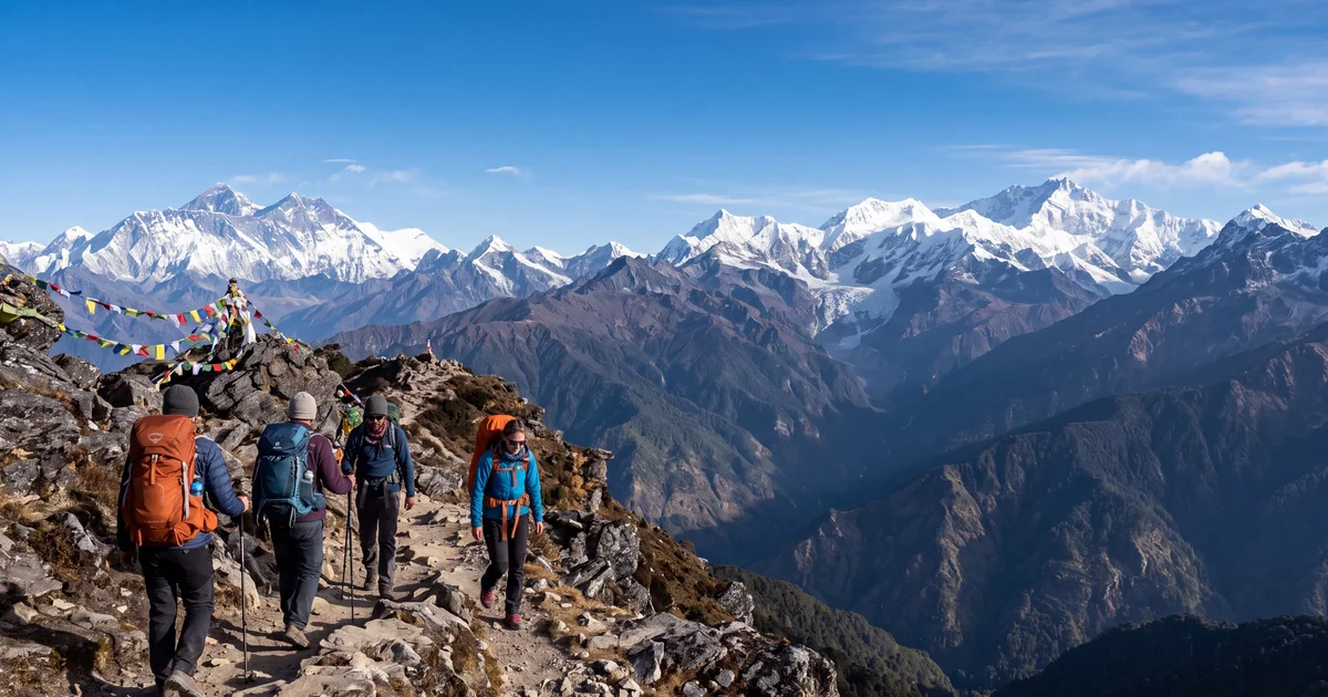
Sandakphu is the highest point in West Bengal at 3,636 metres. It sits on the India Nepal border along the Singalila Ridge, and on a clear morning you can see four of the world's five highest peaks from its summit. Everest, Kangchenjunga, Lhotse, Makalu. All in one frame, no telephoto lens needed.
That combination is why this trek gets 12,100 searches a month. It is also why the trail from Manebhanjan fills up fast between October and December. If you are planning a Sandakphu trek in 2026, here is what actually matters: the route options, the right month, and how to get a spot with a group that handles permits and logistics.
TL;DR
- Sandakphu summit (3,636 m) shows you Everest, Kangchenjunga, Lhotse, and Makalu on clear mornings.
- Best months: October to November for views, April for rhododendrons.
- Trek is 4 to 5 days, moderate difficulty, no technical sections.
- Start point is Manebhanjan (28 km from Darjeeling). Permit required for Singalila National Park.
- Group treks cost ₹8,000 to ₹15,000 including meals, guide, and stays.
The Route: Manebhanjan to Sandakphu (and Optional Phalut Extension)
The standard Sandakphu trek follows one main route with a popular extension to Phalut. Here is the day by day breakdown that most operators run:
Day 1: Manebhanjan to Tumling (11 km, 6 to 7 hours) Starting elevation 2,134 metres, ending at 2,970 metres. The first day hits hard because you gain 800+ metres. The trail passes through Chitrey village and dense forest before emerging at Tumling, a small settlement on the ridge with basic teahouses. This is where you get your first taste of the views.
Day 2: Tumling to Kalipokhri (14 km, 6 to 7 hours) A longer day but more gradual. You walk along the Indo Nepal border ridge through rhododendron forests. Kalipokhri (3,185 metres) has a sacred black lake and basic accommodation. The views open up significantly today.
Day 3: Kalipokhri to Sandakphu summit (6 km, 3 to 4 hours) Short day in distance but you push to 3,636 metres. Most groups arrive by early afternoon and rest. The sunset views from Sandakphu are extraordinary on clear days.
Day 4: Sandakphu sunrise, then descent to Gurdum/Srikhola (16 km, 7 to 8 hours) Wake at 4:30 AM for the sunrise panorama. This is the main event. After breakfast, descend via Gurdum to Srikhola (2,000 metres). Alternatively some groups descend to Rimbik.
The Phalut extension (adds 1 day): From Sandakphu, walk 21 km along the ridge to Phalut (3,600 metres) and descend to Gorkhey. Phalut offers slightly different angles of the same peaks and much fewer trekkers. Worth it if you have the extra day.
When Should You Go? The Two Windows
October to mid December (primary window): The post monsoon months are why Sandakphu exists on most trekkers' lists. Skies clear dramatically after September. October mornings routinely offer 100+ km visibility. Temperatures at summit: 5°C day, minus 5°C night in October, dropping to minus 10°C by December. November is statistically the clearest month.
April to May (secondary window): The rhododendrons along the Singalila Ridge bloom between 2,500 and 3,500 metres. The trail turns red, pink, and white. Views are hazier than autumn but the colours compensate. Temperatures are milder: 10°C day, 0°C to 2°C night at summit.
What about winter (January to February)? Possible but harsh. Snow covers the trail above 3,000 metres. Temperatures drop to minus 15°C at night. Most teahouses close. Only experienced cold weather trekkers with proper gear should attempt it. Views can be extraordinary when it is not snowing.
One caveat about the "best time" advice online: October weekends are now so popular that Tumling and Sandakphu lodges fill completely. Book through an operator or carry camping gear if you plan an October weekend start.
How Hard Is the Sandakphu Trek?
The Sandakphu trek is rated moderate. Here is what that means in practice:
The trail has no rock climbing, no scrambling, no river crossings, and no exposed ridges. It follows a defined path (parts of it are a jeep road) from start to summit. The challenge is sustained distance and altitude gain over 4 days, not technical difficulty.
Daily distances range from 6 to 16 km. The total trek covers about 47 km one way with 2,200 metres of cumulative elevation gain. Day 1 (Manebhanjan to Tumling) is the hardest because you gain 800 metres in 11 km and your body is adjusting.
Fitness requirement: if you walk 12 to 15 km regularly on undulating terrain, you can do this trek. Altitude affects everyone differently, so slow pacing on Day 1 matters more than raw fitness. Drink 3 to 4 litres of water daily. AMS symptoms (headache, nausea) are uncommon below 3,500 metres with proper acclimatisation but not impossible.
First timers often struggle with the cold more than the walking. Below 0°C nights at Sandakphu surprise people who pack for "a short October trek." Layer properly: thermal base, fleece mid, down jacket for mornings and nights.
Getting to Manebhanjan: The Logistics
Manebhanjan (2,134 metres) is the trailhead. Getting there involves multiple legs:
From anywhere in India: Fly to Bagdogra (IXB). Direct flights operate from Delhi, Mumbai, Bangalore, Kolkata, and Chennai. From Bagdogra, a shared jeep to Darjeeling costs ₹250 to ₹400 and takes 3 hours on the Hill Cart Road. A private taxi costs ₹2,500 to ₹3,000.
From Kolkata: The Darjeeling Mail overnight train to NJP (New Jalpaiguri) departs Sealdah at 10 PM, arrives 8 AM. From NJP, same shared jeep to Darjeeling (3 hours).
Darjeeling to Manebhanjan: 28 km, 45 minutes by shared jeep (₹100) or private vehicle (₹800 to ₹1,000). Most operators pick you up from Darjeeling and handle this transfer.
Permits: You need a Singalila National Park entry permit (₹200 for Indians, ₹500 for foreigners). A licensed guide is mandatory inside the park. Group operators handle all permits as part of the package. Solo trekkers can arrange guides and permits at the park office in Manebhanjan, but booking 2 weeks ahead in October is wise.
What Does a Group Trek Cost?
For a 4 to 5 day Sandakphu group trek, expect to pay between ₹8,000 and ₹15,000 per person. That typically includes:
Meals (breakfast, packed lunch, dinner), accommodation in teahouses or tents, an experienced guide, park permits, and a porter for common gear. It does not usually include transport from Bagdogra or Darjeeling to Manebhanjan, personal insurance, or cold weather gear rental.
Budget operators at the ₹8,000 end use basic teahouses with shared rooms and thin mattresses. Mid range operators (₹12,000 to ₹15,000) offer better food, smaller groups (8 to 12 people versus 20+), and sometimes sleeping bags included.
Browse group departures for the Sandakphu trek on TripzSearch to compare dates, prices, and what is included across operators. The Himalayan treks collection also shows other options in the same season if Sandakphu dates don't work.
The View from the Top: What You Actually See
Standing on the Sandakphu summit at sunrise, the Himalayan panorama stretches across roughly 300 km. From left to right (west to east):
Everest (8,849 metres) appears as a dark pyramid between Lhotse and Nuptse. It looks smaller than you expect because it is 150 km away. Lhotse (8,516 metres) sits immediately right of Everest. Makalu (8,485 metres) is further right, a distinct steep pyramid. Then the view pivots east to Kangchenjunga (8,586 metres), which dominates because it is only 45 km away and looks massive.
On the clearest mornings (typically late October and November), you can also spot the Tibetan plateau behind Everest. The Sleeping Buddha formation, where Kangchenjunga and its neighbours form the shape of a reclining figure, is visible from Sandakphu.
Photography tip: be at the summit by 5:15 AM. The first light hits the peaks around 5:30 AM in October, turning them gold then white over 20 minutes. By 7 AM haze builds from the valleys below and contrast drops.
Sandakphu vs Other Himalayan Treks: How It Compares
The Sandakphu trek occupies a specific niche. It is not technically difficult. It does not reach extreme altitudes. It does not cross glaciers or snow passes. What it does offer is arguably the best mountain panorama accessible to moderate trekkers in India.
Compared to Kedarkantha (3,800 metres, Uttarakhand): Kedarkantha is shorter (4 days), reaches a slightly higher summit, and has better camping spots. But its views are limited to nearby Garhwal peaks. Sandakphu's 4 eight thousanders in one frame is unique.
Compared to Roopkund (5,029 metres, Uttarakhand): Roopkund is harder, higher, and more dangerous. It offers a mysterious skeleton lake at the summit. But the Himalayan views from Sandakphu are wider and more iconic.
For someone choosing their first Himalayan trek, Sandakphu strikes the right balance: achievable fitness requirement, no altitude sickness risk for most people (under 4,000 metres), stunning payoff at the top, and reliable group departures from October to December.
Check available Himalayan trek departures from your city on TripzSearch if you want to compare options for the same season.
Packing for Sandakphu: The Non Negotiables
Skip the generic packing lists. For Sandakphu specifically in October to November:
Warmth is the priority. At minus 5°C to minus 10°C night temperatures, you need a down jacket rated to minus 10°C, thermal inners (merino wool preferred), a balaclava or buff for summit morning, and thick woollen or heated socks. Gloves that let you operate a camera are worth the investment.
Footwear: Waterproof trekking boots with ankle support. The trail has loose gravel sections and mud after rain. Gumboots are available for rent at Manebhanjan if monsoon lingers.
Hydration and sun: At 3,000+ metres and dry post monsoon air, you dehydrate fast. Carry a 2 litre bladder plus a 1 litre bottle. Sunscreen SPF 50+ and UV sunglasses are mandatory because the ridge walk has zero shade for hours.
What you can skip: Crampons, ice axes, rope (not needed). Trekking poles help on descents but are not essential. Most teahouses have charging points, so a massive power bank is overkill.
Frequently asked questions
- What is the best time to do the Sandakphu trek?
- October to mid December gives the clearest Himalayan views and stable weather. April to May is the second window, with rhododendrons in full bloom along the ridge. Avoid January and February unless you are comfortable with temperatures dropping to minus 10°C and heavy snow on the trail.
- How difficult is the Sandakphu trek for beginners?
- It is moderate. The trail has no technical sections or scrambling, but the daily distances are long (12 to 16 km per day) and you gain 2,200 metres over 4 days. If you can walk 15 km on flat ground without stopping, you can do Sandakphu with proper pacing. Prior trekking experience helps but is not mandatory.
- Can I see Mount Everest from Sandakphu?
- Yes. On a clear day from the Sandakphu summit (3,636 metres) you can see Everest, Kangchenjunga, Lhotse, and Makalu. These are four of the five highest peaks on Earth. The view is clearest between 5 AM and 7 AM before haze builds. October and November mornings give the best odds.
- How do I reach Manebhanjan for the Sandakphu trek?
- Manebhanjan is 28 km from Darjeeling town. Fly to Bagdogra airport (IXB), then take a shared jeep or taxi to Darjeeling (3 hours) and another jeep to Manebhanjan (45 minutes). From Kolkata, the overnight train to New Jalpaiguri (NJP) is the budget option, then a jeep to Darjeeling.
- What is the cost of a Sandakphu trek with a group?
- Group departures from operators range between ₹8,000 and ₹15,000 per person for a 4 to 5 day trek including meals, camping or teahouse stays, guide, and permits. The Singalila National Park permit costs ₹200 for Indians. Transport from Darjeeling to Manebhanjan is usually extra.
- Is the Sandakphu trek open during monsoon?
- The trail is technically accessible but the Singalila National Park closes for parts of the monsoon season (usually mid June to September). Heavy rain makes the route muddy and leeches are common. Visibility drops to near zero, defeating the purpose of a trek famous for its views. Avoid June to September.