Roopkund Trek (2026): Route, Mystery Lake and What You Need to Know Before Booking
Plan the Roopkund trek in 2026 with route details, best months, costs and the story behind 600 ancient skeletons at 15,700 ft.
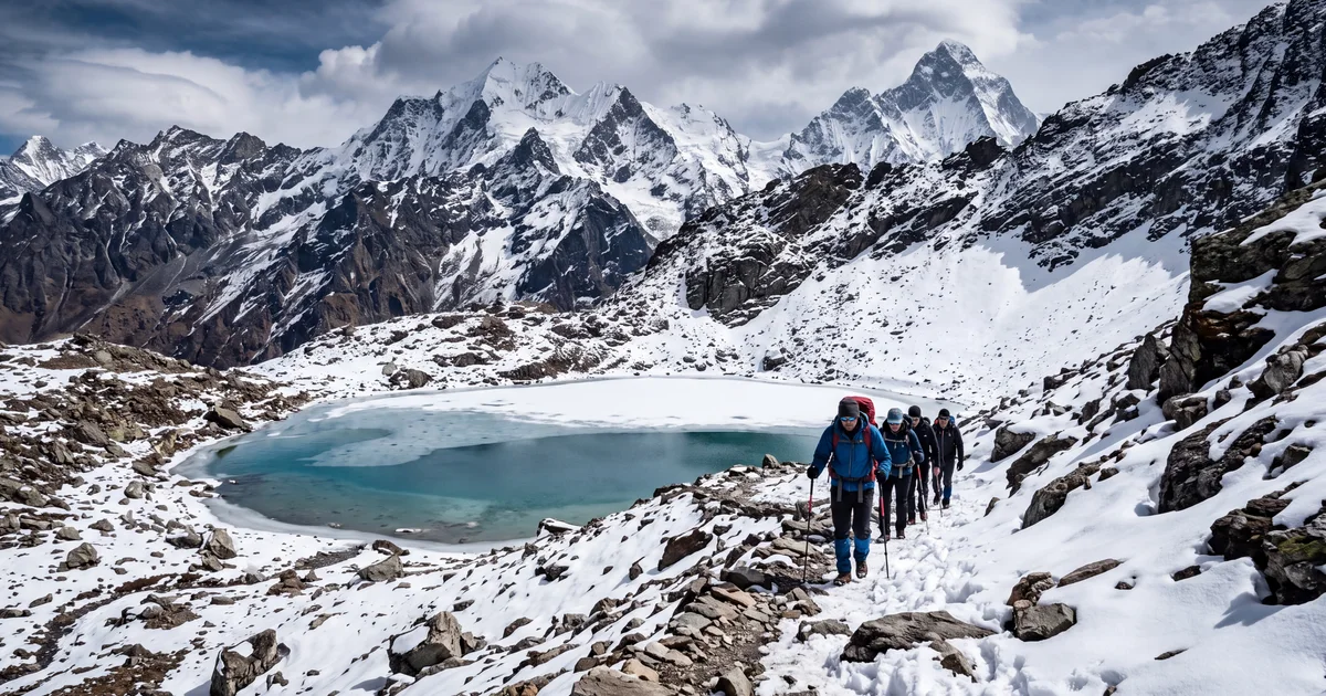
Roopkund sits at 15,700 ft in Uttarakhand's Chamoli district. It is small, about 40 metres across, and frozen for most of the year. None of that would matter if it were not for the roughly 600 human skeletons scattered around its edges.
The bones have been there for centuries. Some date to the 9th century, others to the 17th. Scientists have argued about what killed these people since a forest ranger first stumbled on the remains in 1942, and the best current theory points to a catastrophic hailstorm that caught a large group on the exposed ridge with zero shelter. The second cluster of remains appears to be of Mediterranean origin. That makes the whole thing stranger. Nobody is sure why people from Crete or Greece ended up at a glacial lake in the Garhwal Himalayas, 15,700 ft above sea level.
That mystery is what draws trekkers. But Roopkund is also one of the most scenic routes in Uttarakhand, passing through Bedni Bugyal and Ali Bugyal, two of the largest high altitude meadows in India. Here is what the trek actually involves in 2026.
TL;DR
- Duration: 7 to 8 days from Lohajung and back. About 53 km total.
- Highest point: 15,700 ft (Roopkund Lake). The Junargali ridge above goes to 16,000 ft.
- Difficulty: Moderate to difficult. Prior Himalayan trekking experience recommended.
- Best months: May to June, September to October. Monsoon (July, August) makes the route impassable.
- Cost: 10,000 to 15,000 rupees per person for group packages. Compare departures on TripzSearch.
Why Roopkund Is Not a Beginner Trek
Every season, groups turn back from Bhagwabasa. The altitude is the obvious culprit: 14,000 ft is where headaches become nausea for people who have not acclimatized properly. But the terrain between Bhagwabasa and the lake is the real filter. Loose scree. Snow patches. No defined trail in many sections. It is a 1,500 ft climb where your legs do not get a flat stretch for over two hours.
The first 4 days lull you. Lohajung to Didina is forested and gentle. Bedni Bugyal is flat grassland at 11,500 ft, one of the most beautiful campsites in India. You gain altitude slowly. Then the route above Patar Nachauni steepens dramatically, and the oxygen gets thin enough that every step feels deliberate.
If you have done Kedarkantha or Har Ki Dun, you will manage. If Roopkund is your first Himalayan trek, consider building up to it. The fitness requirement is not exceptional, but altitude tolerance cannot be faked.
What Is the Route from Lohajung?
The standard itinerary runs 7 days. Most operators add a buffer day at Bedni or Bhagwabasa for acclimatization, making it 8.
Day 1: Lohajung (7,600 ft) to Didina village (8,500 ft). A 4 hour walk through oak forests. Didina is a small village with homestays. Some groups camp outside the village instead.
Day 2: Didina to Ali Bugyal (11,000 ft). The trail climbs steeply through forest for the first 2 hours, then opens onto the vast grassland of Ali Bugyal. You can see the Trishul and Nanda Ghunti peaks from here on clear days.
Day 3: Ali Bugyal to Bedni Bugyal (11,500 ft). A short 3 hour walk across undulating meadows. This is your acclimatization day, so take it slow. The campsite sits beside a small lake. On a clear evening, you can count 23 named peaks from Trishul to Chaukhamba without turning your head more than 90 degrees.
Day 4: Bedni Bugyal to Patar Nachauni (12,800 ft). The meadows end and rocky moraine begins. The trail enters a zone of sparse rhododendron bushes before reaching the exposed campsite. It is windier and colder here than anything below.
Day 5: Patar Nachauni to Bhagwabasa (14,100 ft). A steep 4 hour climb over boulders and scree. Bhagwabasa is a desolate campsite below the final push to the lake. Temperatures drop below minus 5°C at night even in May. Sleep here is restless for most people.
Day 6: Bhagwabasa to Roopkund (15,700 ft) and back to Patar Nachauni. The summit day. You start between 4 and 5 AM to catch clear skies. The climb is 1,500 ft over scree, taking 2 to 3 hours. The lake is visible only from the rim. Return the same way, descending to Patar Nachauni for the night. Total walking time: 8 to 10 hours.
Day 7: Patar Nachauni to Lohajung. A long descent covering the full distance in one push. Expect 7 to 8 hours of walking. Your knees will feel every metre of it.
Some groups continue past Roopkund to the Junargali ridge (16,000 ft) for views into the Nanda Devi sanctuary. This adds an hour to summit day and requires stable weather.
When Should You Go?
The two windows exist because of the monsoon. July and August dump enough rain on the lower sections and snow on the upper sections to make the route unsafe. Visibility above Bedni drops to zero for days at a stretch.
May to June is the most popular window. The lower forests are green, the bugyals have wildflowers, and the lake is partially thawed, which means the skeletons are sometimes visible. Snow patches remain above 14,000 ft but are manageable. Temperatures at Bhagwabasa range from minus 2°C to 5°C at night.
September to October gives you post monsoon clarity. The Himalayan views are at their sharpest, and the meadows turn golden. The downside: it is colder, especially on summit day (minus 8°C to minus 12°C at Bhagwabasa in October). Fewer groups operate in this window, so your choices for fixed departures are limited.
One honest caveat: even in the "good" months, the weather above 14,000 ft changes fast. Cloud cover can roll in by 10 AM, and summit attempts that start late see nothing. Book with operators who insist on pre dawn starts on summit day.
How Much Does It Cost?
Group trek packages from Lohajung run between 10,000 and 15,000 rupees for 7 to 8 days. That typically includes camping, all meals on the trail, a certified guide, porters for common gear, and permits.
Getting to Lohajung is separate. A train from Delhi to Kathgodam costs 400 to 1,200 rupees depending on class. The taxi from Kathgodam to Lohajung costs about 3,000 to 4,000 per person in a shared vehicle (8 to 10 hours, one overnight stop sometimes included). Some operators bundle this transfer; others charge extra.
Flights to Dehradun or Pantnagar can cut travel time. From Pantnagar airport, Lohajung is about 7 hours by road. From Bangalore, budget 5,000 to 8,000 for flights to Delhi or Dehradun, plus the onward travel.
Compare group departures and packages on TripzSearch to find dates that match your schedule. Most May and June batches fill up 3 to 4 weeks in advance, so booking early helps.
What Makes the Skeleton Lake So Strange?
The first documented Western discovery of the remains was in 1942, when a forest ranger stumbled on the bones and flesh (preserved by the cold) thinking he had found casualties of the war. DNA analysis published in 2019 by researchers from Harvard, the Max Planck Institute, and Indian institutions revealed two genetically distinct groups.
The larger group (roughly 500 individuals) shares ancestry with present day South Asian populations. They died around 800 CE. The second group, about 14 people, has genetic ties to eastern Mediterranean populations, specifically Crete and Greece. They died much later, around the 17th century. How a group of Greek or Cretan individuals ended up at a remote glacial lake in Uttarakhand remains unexplained.
The hailstorm theory comes from a folk song in the Chamoli region that describes a goddess unleashing "iron balls" on pilgrims who angered her. The terrain around Roopkund offers no shelter. A violent hailstorm on an exposed group at that altitude would kill quickly. Whether that explains all 600 deaths across different centuries is another question, and one that researchers are still working on.
Do You Need Prior Experience?
Yes. Roopkund is not Kedarkantha, where complete beginners summit every weekend in winter. The altitude, the scree climb, and 7 to 8 days of continuous walking put it in a different bracket entirely.
A reasonable preparation checklist:
- At least one completed trek above 12,000 ft. Kedarkantha, Har Ki Dun, or Brahmatal are good precursors.
- The ability to walk 6 to 8 hours on consecutive days without breakdown.
- Comfort sleeping in below zero temperatures (insulated sleeping bag rated to minus 10°C recommended).
- No altitude sickness history above 12,000 ft, or a known tolerance level.
If you have not trekked above 10,000 ft before, consider one of the Himalayan treks at moderate difficulty first. Coming to Roopkund undertrained ruins the experience because you spend summit day managing nausea instead of looking at the lake.
How to Get to Lohajung from Major Cities
From Delhi: Overnight train or bus to Kathgodam (Uttarakhand). Rajdhani Express or Shatabdi gets you there by morning. From Kathgodam, hire a taxi or join the operator's shared vehicle to Lohajung (8 to 10 hours, through Almora and Gwaldam). The road is winding and steep beyond Almora.
From Bangalore or other southern cities: Fly to Delhi (2.5 hours), then follow the Delhi route above. Alternatively, fly to Dehradun and take a taxi via Haridwar and Karnaprayag to Lohajung (12 to 14 hours by road, usually split over 2 days with a halt at Karnaprayag). Check departures from Delhi that include transfers.
The last 30 km before Lohajung is on a narrow mountain road with steep drops. If you are prone to motion sickness, take medication before this stretch.
What Permits Do You Need?
The Roopkund trail passes through the Nanda Devi Biosphere Reserve buffer zone. You need:
- A forest permit from the Uttarakhand Forest Department office in Lohajung. The fee is approximately 600 rupees for Indian nationals.
- A camping permit for each night above Bedni Bugyal.
Organized groups handle both permits on Day 1 at Lohajung. If you are arranging independently, reach Lohajung a day early to sort paperwork. Solo trekking without a registered guide is not allowed on this route.
Packing for Roopkund: What Most People Get Wrong
The most common mistake is underpacking for the cold above 14,000 ft while overpacking for the lower sections where porters carry common gear.
Essentials that matter above Patar Nachauni:
- A sleeping bag rated to minus 10°C (rental available at Lohajung for about 150 rupees per day).
- Waterproof trekking shoes with ankle support. Not sports shoes, not sandals.
- Gaiters if you are trekking in May or June, when snow patches require wading.
- At least 3 layers on top: base layer, fleece, and a windproof outer shell.
- Sunscreen (SPF 50+) and sunglasses with UV protection. Snow glare at 15,000 ft causes snow blindness.
Skip the heavy DSLR unless photography is your primary goal. Your phone in a waterproof pouch handles everything below Bhagwabasa. Above that, your hands are too cold to hold anything for long.
Frequently Asked Questions
The following questions come from common search queries about the Roopkund trek:
Can I see the skeletons at Roopkund? In late May to early June, when the lake partially thaws, bones are sometimes visible around the edges. In September and October, the lake is often frozen or partly covered with fresh snow, hiding most remains. Access to the immediate lakeshore is monitored, and removing any artifact is a criminal offense.
Is there phone signal on the Roopkund trek? You will have intermittent BSNL signal at Lohajung and possibly at Didina. Beyond Didina, there is no signal until you return. Satellite communicators work but most groups carry a walkie talkie set for emergencies instead.
Can I do Roopkund as a solo trekker? Not without a registered guide. The forest department requires organized groups with certified guides. You can join a fixed departure as a solo traveller and be grouped with others. Browse upcoming dates on TripzSearch trips.
Frequently asked questions
- What is the mystery behind Roopkund Lake?
- Roopkund contains the skeletal remains of roughly 600 people. Carbon dating places them across multiple centuries, with the largest group dying around the 9th century, likely from a sudden hailstorm at altitude. A second group appears to be of Mediterranean origin from the 17th or 18th century. The bones are visible when the snow melts in late summer.
- How difficult is the Roopkund trek?
- It is rated moderate to difficult. The trek covers about 53 km over 7 to 8 days with the highest point at 15,700 ft. The stretch from Bhagwabasa to Roopkund is steep scree at altitude, which tests both lungs and knees. Prior experience on at least one Himalayan trek of 12,000 ft or above is strongly recommended.
- What is the best time to do the Roopkund trek?
- May to June and September to October are the two windows. May gives clear skies and some snow near the lake. September offers post monsoon greens on the lower sections but can be colder at the top. July and August are out because of heavy monsoon rain and zero visibility above Bedni Bugyal.
- How much does the Roopkund trek cost in 2026?
- Group packages range from 10,000 to 15,000 rupees per person for 7 to 8 days. That covers camping, meals, guides, and porters from Lohajung. Add your travel to Kathgodam or Rishikesh separately, typically 2,000 to 4,000 depending on whether you take a train or bus from Delhi.
- Is the Roopkund trek currently open?
- As of 2026, the trek route is open with permits. There were restrictions in previous years due to ecological concerns, but the Uttarakhand forest department currently issues passes for organized groups through Lohajung. Solo trekking without a registered guide is not permitted.
- How do I reach Lohajung for the Roopkund trek?
- From Delhi, take an overnight bus or train to Kathgodam (7 hours). From Kathgodam, a taxi or shared vehicle to Lohajung takes 8 to 10 hours via Almora and Debal. Most group operators include the Kathgodam to Lohajung transfer in their package.