Pangarchulla Peak Trek (2026): Route, Summit Day and Group Departures
Everything you need for the Pangarchulla trek in 2026: route from Joshimath, summit day reality, best months, and how to find group departures.
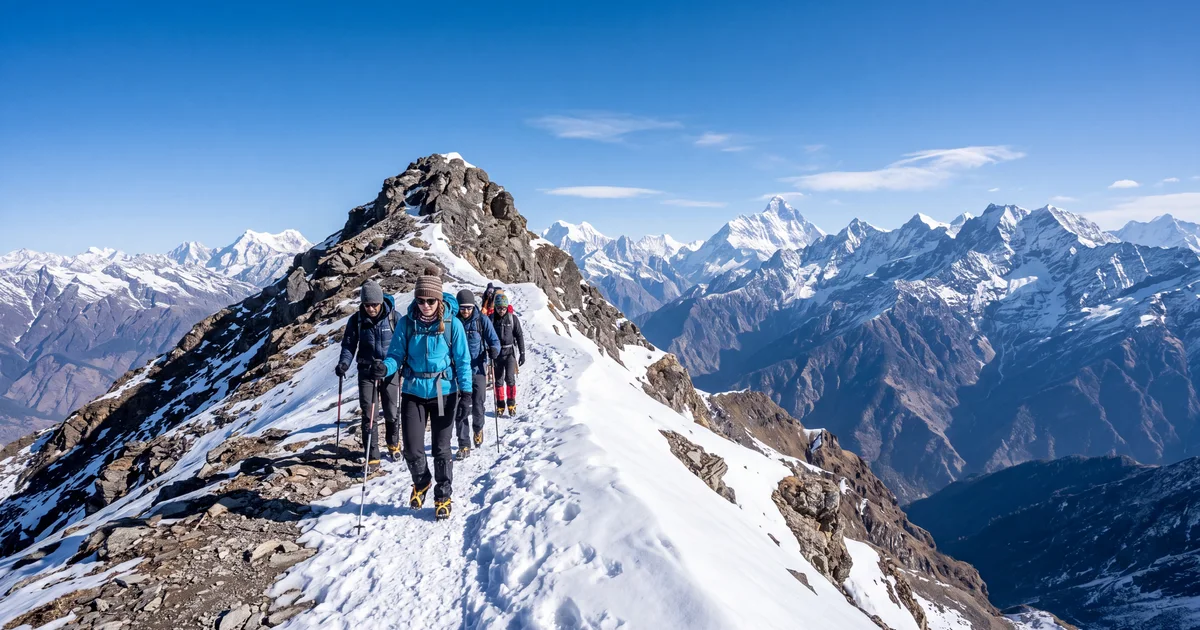
Pangarchulla peak sits at 4,590 metres in the Garhwal Himalayas, directly above the Kuari Pass trail that most moderate trekkers already know. The summit gives you a 360 degree panorama of Nanda Devi, Dronagiri, Hathi Ghoda, Chaukhamba, and Kamet. Five peaks above 7,000 metres visible from one spot. That view is the entire reason this trek exists.
The catch: getting to that view requires one genuinely hard day. The approach through oak and rhododendron forests is pleasant, the campsites at Gorson Bugyal and Tali Lake are sheltered, but summit day involves a steep 60 to 70 degree snow slope that separates Pangarchulla from easier treks like Kedarkantha or Kuari Pass. If the summit push does not intimidate you, this might be the best view to effort ratio in Uttarakhand.
TL;DR
- Pangarchulla peak (4,590 m) is a moderate to difficult trek from Joshimath, with one hard summit day on steep snow.
- Best window: March to mid April when snow is firm and visibility is clearest.
- Total distance is about 28 km over 5 to 6 days. The approach is moderate; the summit push is not.
- You need prior Himalayan experience (at least one trek above 12,000 feet) and basic crampon fitness.
- Group departures with gear, guide, and transport from Rishikesh are listed on TripzSearch.
What is the Pangarchulla trek route?
The standard itinerary runs 5 to 6 days from Dhak village (15 km from Joshimath) and follows this pattern:
Day 1: Dhak to Gulling (2,800 m, 4 km). A short walk through terraced fields and mixed forest. The trail is clear and the altitude gain is gentle. Most groups reach camp by early afternoon.
Day 2: Gulling to Khullara (3,500 m, 6 km). The forest thickens. Oak gives way to birch and rhododendron as you climb. In late March, the rhododendrons bloom red along the trail between 3,000 and 3,400 metres. Khullara is a meadow campsite with views opening up toward Hathi Ghoda peak.
Day 3: Khullara to Tali Lake (3,900 m, 5 km). You cross the Kuari Pass trail and continue ascending. Tali Lake is frozen until late March. The campsite sits exposed to wind, so expect a cold night (minus 5 to minus 10°C in March). Some operators use a slightly lower camp at 3,700 m if conditions are harsh.
Day 4: Summit day (4,590 m and back to Khullara, 10 km total). The early start is typically 2 to 3 AM. You gain 700 metres in about 3 km. The first hour is a gradual snow walk. The final 300 metres is the crux: a steep snow wall at 60 to 70 degrees that requires crampons, an ice axe, and a fixed rope. Summit time is usually between 7 and 9 AM. The descent back to Khullara covers the return through Tali Lake and takes 5 to 6 hours.
Day 5: Khullara to Dhak (10 km). A straightforward descent retracing the approach route. Most groups reach Joshimath by evening.
One caveat about Day 4: summit success depends heavily on snow conditions. If it snowed recently, the fixed rope section becomes slower and the group backs up. Operators with smaller batch sizes (8 to 12 people) have significantly higher summit success rates than those running 20 plus groups.
How hard is the summit day really?
This is where Pangarchulla separates itself from treks like Kedarkantha or Har Ki Dun. Those treks might have snow, but never a sustained steep slope that requires technical gear.
The final 300 metres to the Pangarchulla summit demands three things: crampon confidence on steep terrain, the cardiovascular fitness to climb at 4,400 metres, and mental comfort on an exposed slope where a slip without self arrest would have consequences. Fixed ropes are in place (operators set them each season), but you still need to ascend using your own legs and crampons. This is not a pull yourself up the rope situation.
In practical terms: if you can climb a steep staircase for 45 minutes continuously at sea level without stopping, you have roughly the leg endurance needed. The altitude makes it feel three times harder.
About 80% of trekkers in a well organized March batch summit successfully. That number drops in winter (40 to 50%) and during late April when slushy snow makes the slope unstable after 9 AM. If your group starts late (after 4 AM from high camp), your chances decrease measurably.
When should I go?
March to mid April is the answer for almost everyone. Here is why, broken down:
The snow on the summit slope needs to be firm. Too icy (January, February) and crampons skate. Too soft (late April, May) and you post hole with every step. The March sweet spot gives you consolidated neve that accepts crampon points cleanly and stays stable until mid morning.
Visibility matters more here than on most treks because the payoff is entirely the summit panorama. March and April have the clearest mornings before pre monsoon haze builds. The Nanda Devi wall is visible from the summit on 8 out of 10 March mornings. By May, that ratio drops to maybe 5 out of 10.
Temperatures at high camp (3,900 m): minus 8 to minus 12°C in March nights, rising to minus 2 to minus 5°C in April. Your operator should provide a minus 10°C rated sleeping bag. If they do not list the bag rating, ask before booking.
My opinion: early March (first two weeks) gives the best combination of firm snow and clear views. The trade off is colder nights and shorter days for the summit push.
How do I reach the trailhead?
Joshimath in Chamoli district is the gateway town. From there, it is a 30 minute drive to Dhak village where the trek begins.
From Delhi (by road): Delhi to Joshimath is 500 km via Rishikesh, Devprayag, and Karnaprayag. The drive takes 12 to 14 hours in a sedan, longer in a bus. Overnight UPSRTC and private Volvo buses run from Delhi ISBT Kashmere Gate to Joshimath, departing at 8 to 9 PM and arriving by noon the next day.
From Delhi (by air): Fly to Dehradun Jolly Grant airport (1 hour flight). Then drive Dehradun to Joshimath: 9 to 10 hours via Rishikesh and the Badrinath highway. Most group treks arrange a pickup from Rishikesh or Haridwar, which cuts the self drive hassle.
From Bangalore: Fly to Delhi or Dehradun (3 hours). Then follow the above road route. Budget two full travel days each way. Group trips that include Himalayan treks from southern cities typically build these travel days into the itinerary.
One thing to know about the Joshimath road: landslides between June and September close it regularly. The Helang bypass has improved reliability since 2024, but always confirm road status 48 hours before your departure. Check the Uttarakhand PWD advisories or call your operator.
What gear do I need?
Your trek operator should provide tents, sleeping bags, crampons, gaiters, and an ice axe for summit day. What you carry yourself:
Trekking boots: waterproof, ankle high, with a stiff sole that crampons can strap onto. Soft soled shoes do not hold crampons well and are genuinely dangerous on the summit slope. If you own flexible trail runners and nothing else, rent proper boots from Rishikesh (Decathlon Rishikesh stocks Quechua Trek 500 at ₹4,500, or rent from local gear shops at ₹200 per day).
Layers: a base layer (merino or synthetic), a fleece mid layer, and a windproof outer shell. For summit day, add a down jacket (600 fill or above). You will start at minus 10°C in the dark and be sweating by the time the sun hits the slope.
Sun protection: at 4,500 metres the UV is severe. Sunscreen SPF 50, glacier sunglasses (category 4), and a balaclava or buff that covers your neck. Snow blindness is a real risk if you skip proper eyewear.
Water: carry 2 litres minimum for summit day. Water sources freeze overnight, so fill bottles the evening before and keep them inside your sleeping bag to prevent freezing.
How to find group departures
Fixed departure group treks to Pangarchulla run from late February through April every year. Most depart from Rishikesh or Haridwar with transport to Joshimath included.
When comparing operators, check three things: batch size (smaller is better for summit success), whether they provide mountaineering certified guides for the summit push (not just trek leaders), and the all inclusive cost versus base cost plus extras model. Some operators quote ₹8,000 base but charge ₹3,000 extra for crampon rental, transport, and sleeping bag. Others quote ₹14,000 all inclusive.
TripzSearch lists Himalayan trek departures with the real operator name, actual reviews from past trekkers, and transparent pricing. You can compare batch sizes and dates without filling out enquiry forms on five different websites.
For trips from Delhi that include Pangarchulla in peak season, filtered results show departure dates and remaining spots. Book 3 to 4 weeks ahead for March batches; they fill by late January.
Pangarchulla vs Kuari Pass: which should you do?
Kuari Pass (3,876 m) shares the first two days of approach with Pangarchulla but stops at the pass without attempting the peak. It is rated easy to moderate and requires no technical gear.
If you have never trekked above 12,000 feet, do Kuari Pass first. The views from the pass itself (Nanda Devi, Dronagiri, Kamet) are excellent. You lose the intimate summit panorama and the bragging rights, but you gain a trek with zero technical risk.
If you have done Kedarkantha, Brahmatal, or any trek where you walked on snow for extended stretches, and you have reasonable cardiovascular fitness, Pangarchulla is the logical next step. The summit day is harder than anything on those treks, but the approach is comparable.
My take: Kuari Pass is the safe choice. Pangarchulla is the rewarding one. They are not interchangeable, and operators who pitch Pangarchulla as "Kuari Pass plus a bonus summit" are underselling the difficulty gap. That final 300 metres is a different category of effort.
Frequently asked questions
- How difficult is the Pangarchulla trek?
- Pangarchulla is rated moderate to difficult. The first three days involve gradual ascent through forests, but summit day requires climbing a steep 60 to 70 degree snow slope for the final 300 metres. Basic crampon use is necessary. If you have done Kedarkantha or Brahmatal, you are ready for the approach but not necessarily the summit push.
- What is the best time for Pangarchulla trek?
- March to mid April offers the best summit window. Snow is firm enough for crampon traction, days are longer for an early start, and visibility is clearest. Late April onwards the snow softens and the slope becomes slushy by 9 AM, making the summit push riskier.
- Can beginners attempt the Pangarchulla trek?
- The approach is beginner friendly, but the summit is not. Most operators require at least one prior Himalayan trek at 12,000 feet or above. If you have never used crampons or walked on steep snow, the summit day will be a problem. Some groups offer a non summit variant ending at Kuari Pass.
- How do I reach Joshimath for the Pangarchulla trek?
- Fly to Dehradun (Jolly Grant airport) and drive to Joshimath, which takes 9 to 10 hours via Rishikesh and Karnaprayag. Alternatively, take an overnight bus from Delhi ISBT to Joshimath (14 to 16 hours). Most group treks include transport from Rishikesh or Haridwar.
- What is the total distance of Pangarchulla trek?
- The standard route covers about 28 km over 5 to 6 days. Daily walking averages 5 to 7 km except summit day, which is shorter in distance (about 3 km one way from high camp) but takes 6 to 8 hours due to the steep snow section and altitude.
- Is Pangarchulla trek open in January or February?
- Some operators run winter batches in late January and February, but conditions are extreme. Temperatures drop to minus 15°C at high camp, the snow slope is icy rather than firm, and daylight hours are shorter. Winter attempts have a lower summit success rate (roughly 40 to 50% vs 80% in March).