Kudremukh Trek (2026): Route, Best Season and Group Treks from Bangalore
Complete Kudremukh trek guide covering the Mullodi route, permits, difficulty, best months, and how to find group departures from Bangalore.
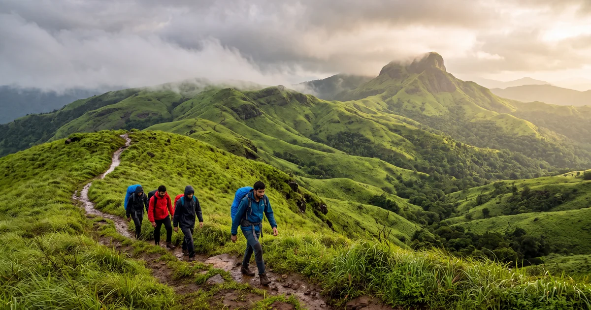
Kudremukh means "horse face" in Kannada. The name comes from the peak's profile when viewed from the west, a ridge that curves and drops like a horse's muzzle. At 1,894 metres it is the third highest peak in Karnataka, and the trek to reach it is one of the most rewarding Western Ghats experiences available from Bangalore.
The trail runs 11 km one way from Mullodi village through dense shola forest, open grasslands, and a final steep ridge with no shade. On a clear day the summit gives you a view that stretches from the Arabian Sea coast to the Baba Budangiri range. In monsoon the same grasslands turn a green so intense it looks edited in photographs. It is not.
What makes Kudremukh different from easier Karnataka treks: the distance. A 22 km round trip with 1,200 metres of gain is a full day of walking. Most people underestimate this. If Tadiandamol felt hard, Kudremukh will feel significantly harder.
TL;DR
- 22 km round trip from Mullodi village, rated moderate to hard. Elevation gain: 1,200 metres.
- Best months: October to February for views. June to September for monsoon green (slippery, low visibility).
- Permit required from the Kudremukh National Park forest office. Operators handle this.
- Drive from Bangalore: 330 km, 7 to 8 hours via Hassan and Kalasa.
- Group departures run most weekends October to January. Compare on TripzSearch.
How do I reach the Kudremukh trek base from Bangalore?
The base village is Mullodi, a small settlement at the edge of Kudremukh National Park in Chikkamagaluru district. Two routes get you there from Bangalore.
Via Hassan and Kalasa (330 km, 7 to 8 hours). Take NH75 towards Mangalore, exit at Hassan, continue through Belur to Kalasa, then a forest road to Mullodi. This is the standard route and what most groups use. The last 15 km from Kalasa to Mullodi is a single lane road through the park, no streetlights, occasional potholes.
Via Chikkamagaluru (310 km, 7 hours). Slightly shorter on paper but the road quality after Chikkamagaluru is worse. Most operators avoid this because the forest road section is longer and rougher.
Group operators typically leave Bangalore on Friday night at 9 or 10 PM and reach Mullodi by 4 to 5 AM Saturday. You sleep a few hours at the campsite, then start the trek at dawn. This timing works because the trail is better done in morning cool. Afternoon heat on the exposed grasslands above 1,500 metres drains energy fast.
Public transport exists but is impractical. You would need a bus to Kalasa (5 hours from Bangalore via KSRTC) and then a local jeep to Mullodi, which runs infrequently.
What is the Kudremukh trek route like?
The standard route goes: Mullodi village to the national park gate (1 km, flat), then a forest trail to Ontimara (5 km, gradual ascent through shola and semi evergreen forest), then open grassland to the summit ridge (5 km, steep in the last section).
Mullodi to Ontimara (first 5 km). Dense forest with a clear trail. You cross two small streams (dry between January and May). The gradient is gentle, around 200 metres of gain over 5 km. This section is shaded and comfortable. Watch for leeches during monsoon; they are aggressive between June and September from the park gate onwards.
Ontimara to the grasslands (km 5 to 8). The canopy thins. You enter rolling grassland at about 1,400 metres. The trail becomes less defined here because multiple paths branch across the meadow. If you do not have a guide, GPS helps. In monsoon, tall grass (over 2 metres in places) can obscure the route entirely.
Grasslands to summit (km 8 to 11). The hardest section. Open, exposed, and steep. The last 3 km gain about 500 metres. There is no shade and no water source. On a sunny day between 10 AM and 2 PM, this stretch is punishing. Wind at the ridge is constant and cold in winter, so carry a windbreaker even if the valley below feels warm.
The summit itself is not a single point but a ridge. You walk along it for about 200 metres with views on both sides. If the sky is clear, you can see the Netravathi river system below, the coast beyond, and Baba Budangiri to the east.
When should I trek Kudremukh?
October to February. The best window. Skies are clear 4 days out of 5, temperatures at the summit sit between 8 and 15°C, and the grasslands are golden brown. January mornings can drop to 5°C at the campsite. Views are at their best in November and December when post monsoon clarity peaks.
June to September (monsoon). The grasslands turn vivid green and dozens of seasonal waterfalls appear along the forest trail. But visibility drops. Clouds roll in by 9 AM most days, and you may summit in a white wall of fog with zero view. The trail gets slippery, leeches are everywhere below 1,500 metres, and stream crossings swell. Experienced trekkers who care more about the landscape than the summit panorama love this season. Everyone else should avoid it.
March to May. Dry and hazy. The grasslands turn brown and crispy. Heat makes the exposed summit section uncomfortable after 9 AM. Water sources may be dry. Only worth it if your schedule leaves no other option.
One honest caveat: even in peak season, Kudremukh is not guaranteed clear. The Western Ghats trap moisture unpredictably. About 1 in 4 October treks still hits cloud cover at the summit. You cannot control this. Enjoy the walk regardless.
Do I need a permit and what does it cost?
Kudremukh National Park is a protected area. You need a permit from the Karnataka Forest Department to enter. Here is how it works.
Group operators handle the permit as part of their package. They submit a batch application with all participant names, typically 3 to 7 days before the trek date. The permit costs approximately 300 to 600 per person (as of 2025; check current rates), which operators include in their pricing.
Individual trekkers can get a permit at the Range Forest Office in Mullodi, but availability is not guaranteed on the spot. Apply in advance if possible. You need a valid photo ID, the exact dates, and the number in your group.
The forest department limits daily entries, especially during monsoon when trails are fragile. This is one reason group departures fill up weeks ahead during peak season. If you see an October departure with available spots, book it. They sell out.
How does Kudremukh compare to other Karnataka treks?
For context, here is where Kudremukh sits among its neighbours.
Tadiandamol (Coorg) is shorter (15 km round trip), lower (1,748 metres), and easier on the legs. The view from the top is good but not as dramatic as Kudremukh. Think of Tadiandamol as the warmup.
Kumara Parvatha is longer (about 18 km one way to the peak from Kukke Subramanya) and harder. The descent on the return is famously knee destroying. But Kumara Parvatha requires an overnight camp and two full days, so it is a different category.
Kudremukh sits between these two. Harder than Tadiandamol, easier than Kumara Parvatha, and doable in a single long day if you start early enough. Most groups that leave at 5 AM are back at Mullodi by 3 PM.
My strong opinion: Kudremukh has the best summit view of any trek in Karnataka. The 360 degree exposure, the horse face ridge walk, and the scale of the surrounding national park are unmatched south of the Sahyadris. Tadiandamol is prettier in monsoon. Kumara Parvatha is a bigger challenge. But Kudremukh gives you the best payoff per unit of effort.
What should I pack for Kudremukh?
Keep it light. You are walking 22 km in a day with no overnight gear (unless your group camps at Ontimara).
Water: carry 3 litres minimum. There is a stream crossing at km 2 and km 4, but nothing reliable beyond Ontimara. In peak season, 2 litres is not enough for the exposed grassland section.
Shoes: trail running shoes with good grip work on dry grassland. If trekking in monsoon, waterproof hiking boots are non negotiable. The trail becomes a stream in places between June and August.
Layers: a light windbreaker for the summit ridge and a warm layer for early morning starts. Between October and January the predawn temperature at Mullodi sits around 12°C, and the summit wind chill drops it further.
Sun protection matters on the grasslands. There is no shade for 6 km. A hat, sunscreen, and sunglasses make the difference between enjoying the walk and suffering through it.
Food: pack high calorie snacks (nuts, chikki, fruit). Most groups eat a light breakfast at 4:30 AM and carry lunch for the trail. There are no food stalls between Mullodi and the summit.
How to find a group trek to Kudremukh from Bangalore
Most Bangalore based trek operators run Kudremukh departures on alternate weekends between October and January. Typical format: Friday night departure from Bangalore, Saturday trek, Saturday evening return drive, Sunday morning in Bangalore.
Pricing ranges from 2,800 to 5,500 per person depending on inclusions. Budget operators cover transport, permits, and a guide. Premium ones add meals, camping equipment, and a morning snack at the base.
What to check before booking: guide to trekker ratio (should be 1:10 or better for Kudremukh given the route finding needed in grassland), whether they specify the exact start time (5 AM is ideal; anything after 6 AM means you hit the exposed section in full sun), and their monsoon track record if you are going between June and September.
Compare operators, reviews, and departure dates for Kudremukh group treks from Bangalore on TripzSearch.
Frequently asked questions
- How difficult is the Kudremukh trek?
- Kudremukh is rated moderate to hard. The trail covers 22 km round trip with about 1,200 metres of elevation gain. The last 3 km to the summit are steep grassland with no tree cover. Fitness wise, you should be able to walk 14 km uphill in a day without major breaks.
- Do I need a permit for Kudremukh trek?
- Yes. Kudremukh falls inside the Kudremukh National Park. You need a forest department permit from the Range Forest Office at Mullodi. Group operators handle this in advance. Individual trekkers should apply at least 3 days before through the Karnataka Forest Department office or at the Mullodi gate.
- What is the best time to trek Kudremukh?
- October to February is ideal for clear views and dry trails. The monsoon months (June to September) turn the grasslands electric green but visibility drops and the trail gets slippery. March to May is hot and hazy. Most group departures from Bangalore run between October and January.
- How far is Kudremukh trek from Bangalore?
- The drive from Bangalore to Mullodi village (the trek base) is approximately 330 km, taking 7 to 8 hours via Hassan and Kalasa. Most groups leave Bangalore by 9 PM Friday and reach Mullodi by early morning Saturday.
- Can beginners do the Kudremukh trek?
- Beginners with reasonable fitness can manage it, but this should not be your first trek. The distance (22 km in a day if not camping) and the steep final section demand stamina. Do at least two shorter treks like Skandagiri or Tadiandamol before attempting Kudremukh.
- Is camping allowed at Kudremukh peak?
- Camping is not allowed at the summit. The designated campsite is near Ontimara, about 5 km from the peak. If your group camps there, you do the summit push early morning and return to camp. Most single day groups skip camping entirely and complete the round trip in one push.