Harishchandragad Trek from Pune (2026): Kokan Kada Routes, Difficulty & Group Departures
Harishchandragad trek from Pune: all 3 routes compared, Kokan Kada sunrise, monsoon warnings, Shivajinagar buses, and how to pick a group departure.
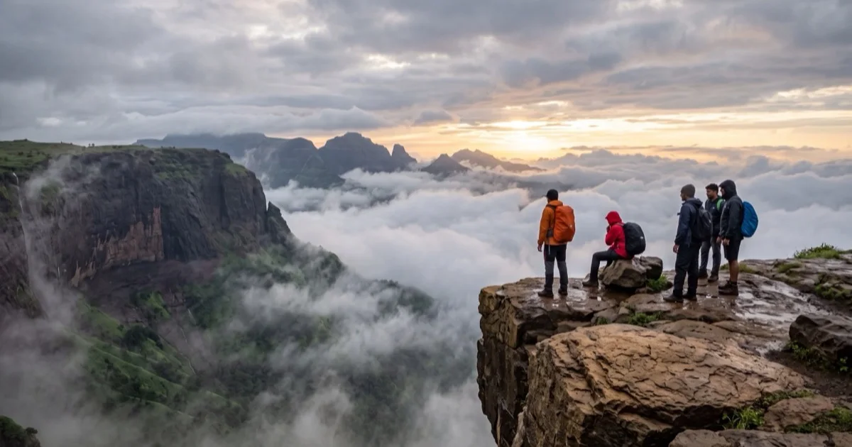
Ask five Pune trekkers for their favourite Sahyadri summit and at least three will say Harishchandragad. The Harishchandragad trek from Pune has become the region's rite of passage: an ancient hill fort at 1,424 metres, a 1,000 year old temple, a cave shrine standing in freezing water, and Kokan Kada, a concave rock wall with close to half a kilometre of air below its lip.
It is also the trek people most often get wrong. Three routes reach the top. They range from a 90 minute walk to a technical gully climb. Pick the wrong one for your group and the day turns miserable fast.
This guide sorts the routes, the logistics from Pune, and the honest season calls.
TL;DR
- Easiest route: Pachnai, 90 minutes to two hours, fine for first timers
- Classic route: Khireshwar via Tolar Khind, three to four hours, moderate
- Experts only: Nalichi Vaat, avoid it entirely in monsoon
- Distance from Pune: 110 km to Khireshwar, about 165 km to Pachnai
- Best months: June to September for greenery, October to February for clear views
- Most groups leave Pune near midnight and summit for sunrise
Why Harishchandragad pulls trekkers out of Pune at midnight
The short answer is Kokan Kada. The cliff is not a straight drop. It curves inward like a cupped hand, so you stand on an overhang with the Konkan plains far below and nothing under your feet but air. In monsoon, clouds boil up the face and spill over the rim. A few lucky mornings each year produce the circular rainbow known as the Brocken spectre, where your own shadow appears inside a halo on the cloud below.
The fort itself is old in a way that few Sahyadri treks match. The Harishchandreshwar temple on the plateau was carved around the 11th century. Caves near it shelter trekkers overnight. The place has held pilgrims, hermits, and now weekend groups for a very long time.
One honest caveat: popularity has a cost. On December and January weekends the plateau can hold several hundred campers, and the caves fill by 8pm. Go on a weekday if silence matters to you.
How difficult is the Harishchandragad trek?
Difficulty here is a routing decision, not a fixed fact. The same fort is a gentle walk from one side and a rope assisted climb from another.
| Route | Base village | Time to top | Grade |
|---|---|---|---|
| Pachnai | Pachnai | 1.5 to 2 hours | Easy |
| Tolar Khind | Khireshwar | 3 to 4 hours | Moderate |
| Nalichi Vaat | Belpada side | 5 hours plus | Hard, technical |
Fitness wise, the moderate route asks for about 700 metres of height gain over rocky steps and one short exposed patch near Tolar Khind where railings now help. Children above ten and reasonably active adults manage it regularly. The descent punishes knees more than the climb. Carry a stick.
My opinion after watching many mixed groups: the biggest mistake is not the route, it is the start time. Groups that begin the Khireshwar climb after 9am in October heat suffer far more than groups that start at 5am in the dark.
The caveat worth repeating: Nalichi Vaat has claimed lives. It is a loose rock gully with rope sections. Do it only with an operator who runs it regularly, and never between June and September.
The three routes, compared properly
Pachnai: the family route
From Pachnai village the trail rises gently through forest and reaches the temple plateau in under two hours. The path is obvious. Villagers run small stalls partway up. In monsoon this route stays the safest of the three, though the last rock patch gets slick.
The trade off is drive time. Pachnai sits on the far side of the massif, about 165 km from Pune via Narayangaon, Otur and Rajur.
Khireshwar and Tolar Khind: the classic
This is the route most Pune group departures use. From Khireshwar village the trail climbs steadily to Tolar Khind, a notch in the ridge, then works up rocky ledges to the plateau. Budget three to four hours up. The 11th century Nageshwar temple at Khireshwar deserves ten minutes before you start.
A real limitation: the approach road matters here. You leave the Malshej Ghat highway at Khubi Phata and cover roughly 5 km to Khireshwar along the reservoir, so factor that into timing if you come by bus.
Nalichi Vaat: the one to earn
A steep gully on the Kokan Kada side with sustained scrambling, loose rock, and rope assisted patches. Strong parties take five to six hours. It is a brilliant, serious day for experienced trekkers with a competent leader. It is a terrible idea for anyone else. Enough said.
How do you reach Harishchandragad from Pune?
By car, the Khireshwar side is simplest: Pune to Alephata on the Nashik highway, left toward Malshej Ghat, then the Khubi Phata turn off. Around 110 km, three to three and a half hours. For Pachnai, drive via Narayangaon and Rajur, about 165 km and four and a half hours.
By bus, take an MSRTC service from Shivajinagar toward Kalyan over Malshej Ghat and get down at Khubi Phata. From there it is a 5 km walk or a shared jeep to Khireshwar. Buses thin out after evening. Plan the return leg before you leave.
The realistic option for most people is a group departure with transport included. Pickups typically run from Shivajinagar, Nal Stop and Nashik Phata between 10pm and midnight, and you sleep, badly, on the drive. Browse the current group treks departing from Pune to see what is running this month.
One honest note on night drives: the Malshej road in monsoon has fog patches and waterfalls landing on the tarmac. Operators who leave earlier and drive slower are worth choosing over the cheapest listing.
What is on top of Harishchandragad?
The plateau rewards slow exploration, so resist the urge to sprint to the cliff and back.
Kedareshwar cave holds a 1.5 metre Shiva linga standing in water cold enough to numb your legs within a minute. Of the four pillars that once surrounded it, one remains standing. Local belief ties the pillars to the four yugas. Wading in is a tradition; do it before the crowd arrives.
The Harishchandreshwar temple is the plateau's centrepiece, carved stone with a 16 metre shikhara, sitting beside the Saptatirtha pond. Taramati peak, a 30 minute walk above the temple, is the true summit at 1,424 metres and throws views across to Naneghat and the Malshej reservoirs.
Then Kokan Kada for sunset. The sun drops straight into the Konkan haze in front of the overhang. It beats the sunrise here, in my view, because the light lands on the cliff face rather than behind it.
Caveat: there are no railings along most of the rim. Wind gusts hit hard after 4pm. Keep three metres back for photos and keep children in hand.
If you stay the night, the caves near the temple sleep 15 to 20 people on a first come basis, and tents go up on the flat ground beyond the pond. Carry a sleeping bag rated near 5°C for winter camps, a headlamp, and three litres of water for the summit day, since the plateau sources need purification. Village families sell simple hot meals, pithla bhakri and tea, near the temple in season. Eat there. It is good food and it keeps the trail economy alive.
Monsoon or winter: when should you go?
June to September turns the plateau into deep green, fills the waterfalls near Tolar Khind, and gives you the cloud theatre at Kokan Kada. It also brings leeches on the Khireshwar trail, slick rock, and days where the view is the inside of a cloud. Roughly one monsoon trip in three gets a clear rim. You accept that lottery going in.
October to February trades drama for clarity. Nights on the plateau drop below 10°C in December and January, sunrise views run long and sharp, and camping is at its best. Summer, March to May, is the season to skip. The climb is shadeless in stretches and afternoon heat on the rock is brutal.
My call: first visit in late September. The grass is still green, the trails have drained, and the crowds have not yet peaked.
Booking a group departure from Pune
Harishchandragad appears on nearly every Pune operator's monsoon calendar, which makes choosing harder, not easier. Three filters do most of the work. First, which route the batch uses; if the listing does not say, ask. Second, group size, since caves and campsites get tight beyond 25 people. Third, whether the leader to trekker ratio is stated at all.
Prices vary with transport, meals and camping gear, so skip the guesswork and see current prices on live group trips. If you are still comparing hills, the wider trek and trip destinations pages help you weigh Harishchandragad against its neighbours before you commit a weekend.
Verified listings show the operator's real name and rating history. Use that. A fort this good deserves a batch that starts on time.
Frequently asked questions
- How difficult is the Harishchandragad trek?
- It depends entirely on the route. Pachnai is easy and takes 90 minutes to two hours, Khireshwar via Tolar Khind is a moderate three to four hour climb, and Nalichi Vaat is a technical gully for experienced trekkers only. Most first timers from Pune should start with Pachnai or Khireshwar.
- How far is Harishchandragad from Pune?
- The Khireshwar base village is about 110 km from Pune via the Malshej Ghat road, roughly a three to three and a half hour drive. The Pachnai base village sits on the other side of the massif and is around 165 km via Narayangaon and Rajur. Most group departures leave Pune between 11pm and midnight to catch sunrise on top.
- Can we do the Harishchandragad trek in one day?
- Yes, from Pachnai it is a comfortable single day trip from Pune, though a long one with about eight hours of driving. Via Khireshwar it becomes a very full day, which is why most groups do it as a night trek or camp on the plateau. An overnight stay lets you catch both sunset and sunrise at Kokan Kada.
- Is Harishchandragad trek safe in monsoon?
- Pachnai and the Tolar Khind route from Khireshwar stay doable in monsoon with decent shoes and some care on the rock patches. Nalichi Vaat should be avoided completely between June and September. Stay well back from the Kokan Kada edge when the wind picks up, as gusts at the rim are strong enough to unbalance you.
- What is the height of Harishchandragad fort?
- The fort plateau tops out at Taramati peak, about 1,424 metres (4,671 ft) above sea level, which makes it one of the highest points in this part of the Sahyadris. The famous Kokan Kada cliff sits just below the summit level. On a clear day you can see deep into the Konkan from the rim.
- Which is the best route for Harishchandragad for beginners?
- Pachnai. The trail is short, well marked, and reaches the temple plateau in under two hours without any exposed climbing. If you want more of a workout with the same safety margin, take the Khireshwar route up through Tolar Khind and descend via Pachnai.